“K K K”
(‘Kimberley
Karavan Kapers’ - Bruce and Audrey)
No: 6
Alice Springs - Katherine -
Kununurra
Thursday 29 May 2014: Day
54. Alice Springs: We’re up early again in the dark to get packed for departure but decide to (finally)
visit the Araluen Cultural Precinct, the premier cultural experience in Alice Springs. An initiative of the NT government,
Araluen comprises an Arts Centre, the Museum of central Australia, an Aviation Museum
and Craft Displays.
 |
Araluen Community Centre |
We did last minute shopping
then called on one of Bruce’s previous work colleagues, Jock McPherson ex
Primac, Roma, who set up his own successful rural agency business here, ‘Territory
Rural McPherson’, several years ago. His clientele are scattered in a radius
stretching many hundreds of kilometres out from AS.
It’s 3pm when the ‘KKK’
combo depart, leaving ‘Alice’ as a diminishing spec in the rear view mirror,
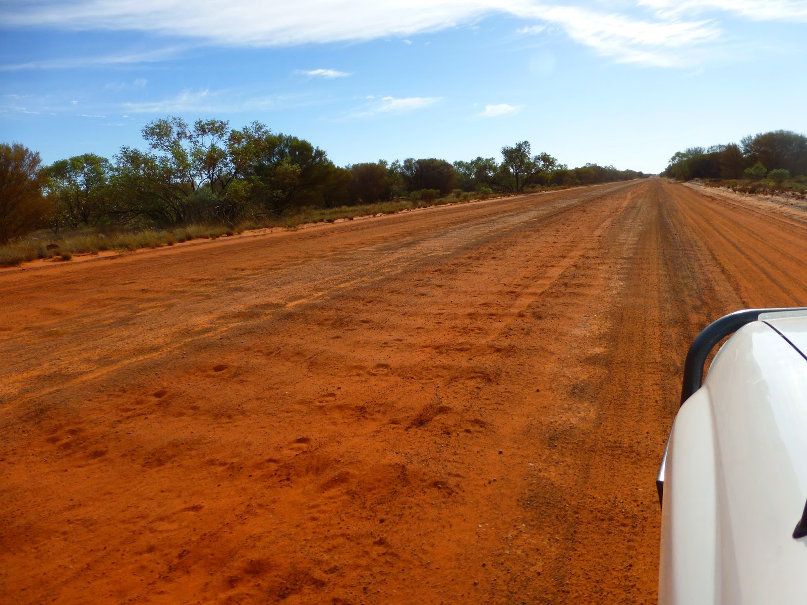
heading northward up the Stuart Highway, and an hour later we pull in to our
previously visited abandoned roadworks gravel pit 2km up the Plenty Highway - a
restful night assured, though a few spots of rain awoke us around 4am. Heavy
noisy spots, but only very few.
 |
| Hitchhiker!! |
Back out to the main highway
by 8.30 next morning and drove north on the Stuart thru mile after mile of
monotonous Mulga scrublands until we reached Aileron Roadhouse, where we inspected aboriginal paintings in the
local Art Shop, ‘cheap and touristy art’.
 |
| Aileron Roadhouse |
Then on another 59km to Ti Tree Roadhouse where we stopped for
smoko, and continued on thru more stunted flat Spinifex scrublands, fading to distant
hills, until we arrived at Barrow Creek
with its restored Overland Telegraph Station, which we pulled in to inspect.
The Overland Telegraph Line with its series of Morse code repeater stations was
completed in 1872, spanning 3600km from Adelaide
to Darwin, and was Australia’s
first telegraphic link to Britain.
Another 92km and we passed through
tiny Wycliffe Well with its UFO
Centre, the background of which we didn’t stop to discover, then a further 17
klicks bought us to Wauchope,
another whistlestop roadhouse. About 10km north of here is ‘The Devils Marbles Conservation Reserve’, an 1,800ha area of gigantic
rounded granite boulders of immense spiritual value to the 4 traditional local
aboriginal tribes, and discovered when surveying the overland telegraph line in
the 1860’s.
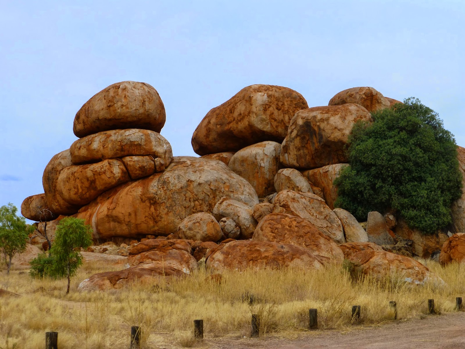 |
| The Devil's Marbles |

It’s a popular camping spot,
as attested by the 35/40 campers already there, and we joined them for the
night, after walking around photographing the sights.
The discovery of gold by a O/T linesman in 1925
quickly led to the establishment of Tennant
Creek, (pop 3000) which was the
morning’s destination, a regional town a further 105 km up the Stuart, famous for
its old Gold Mine just out of town, which we visited, with its now closed Battery,
though gold is said to still exist. We patronised the local Supermarket and
Butcher and were rewarded with the best beef sausages ever!!
 |
| Aboriginal Art Tennant Creel |
Just north of town we
stopped to take a look at the old Tennant Creek Overland Telegraph Station,
again well restored, before heading 12km west up a dirt track to make overnight
camp at another sacred aboriginal site, ‘Kunjarra’, also known as ‘The Pebbles’. A quite scenic area of
eroded granite spheres, though smaller than the Devils Marbles. Like most NT
Nat Parks it offers no water or power, only compositing Toilets.

From
midnight on, on 1st June, a very fresh breeze sprang up the
south-east, (which continued on for many days), quite gusty at times, causing
some concern regards our flapping sun awning, so I got up and checked it, which
bought back memories of windy nights on ‘Envy’ when I had to get out of bed to
check the anchor at 3am in the morning.
Following
our Sunday ‘religion’ of an eggs and bacon breakfast, we left ‘The Pebbles’,
soon passing the well known ‘Threeways Roadhouse’ where the Barkly Hwy to Mt
Isa joins the Stuart, continuing on a further 105km to “Banka Banka Station” campground, passing through much more
interesting grazing lands along the highway, a mix of moderately timbered open
forest, well grassed stony ridges and Mitchell grass Downs, well capable of
fattening cattle in this good season. Livestock look good everywhere.
“Banka Banka” was an important camp for both Aussie and American
soldiers building the Stuart
Highway during WW2. Owned by the American Nelson
Bunker Hunt for some years, it then became part of the huge AMP owned Stanbroke
Pastoral Co, and has since changed hands to indigenous ownership.
 |
| Banka Banka Station |
Apart
from its nice green grassy campground, the original homestead built by the
Ambrose brothers, of mud bricks and bush timber in the 1920’s remains,
magnificently restored by Stanbroke in 2002, under the direction of John Cox (a
fellow BBC school-boy), during his time as CEO.
Just
the one night there and next morning, 2 June, day 58, bright, sunny and windy, we’re
on the move north again, passing through ‘Helen Springs Station’, part of the famous
Kidman pastoral empire when, in his heyday (1920/30’s) Sir Sidney Kidman was
the biggest private land owner in the world, with massive pastoral holdings,
mostly all situated in the arid or semi-arid areas of central Australia.
Elliott is a tiny town, albeit the second largest town of
the Barkly Tableland, 155km from ‘Banka’, and an
important host to the great droving legends along the Barkly Stock Route over 100 years ago. We
filled up with petrol here before driving a very rough dirt track12km out of
town to our next campsite, “Longreach
Waterhole”, a picturesque 200 metre wide stretch of water covering a few kilometres
along Newcastle Creek, and currently home to perhaps 150/200 Pelicans, with
obviously sufficient fish stocks to sustain them.
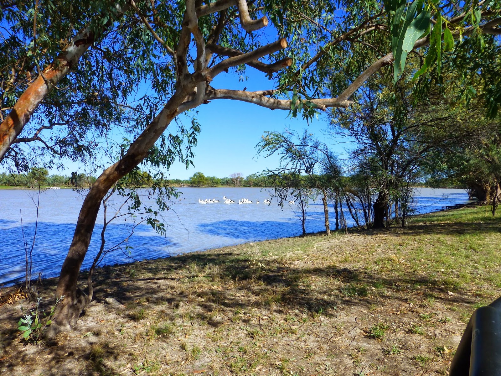

We
set up camp just a few metres from the shady water’s edge, with wading birds in
an anabranch behind us, together with about a dozen or so others campers spread
over half a kilometre of foreshore, under still very windy skies. The Pelicans
provided much interest as they went about their never ending feeding routine most
of the day, a very graceful performance I’d not seen before.


The
Pelicans worked in groups of 10 to 20 paddling as a bunch then, like well
trained water ballerinas, they form a circle and, simultaneously, raise their
wings and tails upwards as they plunge their long necks and beaks underwater for
a period before resuming their normal position with raised beaks to swallow
their catch. A performance as well choreographed as the Bolshoi Ballet! Gracefully
amazing.


After
three days of peaceful R&R we depart Longreach Waterhole at 8am June 5th
and continue 25km up the Stuart Hwy to visit the remnants of old Newcastle Waters town, surrounded by the 10,353 sq km cattle station of the
same name, another of the famous “old name stations” of the Northern Territory,
now held by Consolidated Grazing.
A
highway hoarding farther on boasted the famous meat pies of Dunmarra Roadhouse
somewhere up ahead, so after a period of indulgent gastronomical anticipation, we
finally arrived only to discover there were no “world’s best” pies left, so we
left Dunmarra in a mood between
sulking and sorrow.
Another
50km brings us to Daly Waters with
its famous old Pub that we’ve been hearing wonderful stories about since first
arriving in the Territory, with its ‘Beef and Barramundi’ BBQ Dinners a “must
do”, and by midday Campers and Vans were streaming into the Pub’s campground,
parked cheek to jowl.
 | |||
| Daly Waters Pub Campground |
 |
| Ready for the 'Beef n Barra' Dinner |
The
Daly Waters Pub runs a one-man nightly dinner-show, a performance by “Chilli” of
‘outback song and bawdy humour’ and we fortuitously arrived at the right time
for a special treat. An Aussie film crew were shooting a movie “Last Cab to
Darwin”, live, and we were all ‘extras’ in this un-staged performance, which
we’ll look forward to seeing in Cinema perhaps later this year! A great night
of food and fun and laughter – the stuff memories are made of.
 |
| 'Extras' Ready for the Floor Show |
 |
| Film Crew Working |
Both
days and nights continue very windy from the SE, but the weather’s still warm
when we depart next morning, ever northward, destination Katherine. The
countryside is loosing its semi-arid ‘red centre’ scrublands appearance as we
cruise at our usual 85/90 kph through open forest grasslands, but still the
ubiquitous red anthills, many of them cleverly dressed, by scallywag
travellers, with T shirts, skirts, knickers, bras and hats.
 |
| Anthill Models |
We
drove into Larrimah, just another
whistlestop of perhaps 10 buildings whose only tourism feature is its Pink Panther
Hotel & C’van Park with most everything painted Pink.
How it survives I know not, a dot on the road map living its past glory as an
important WW2 army staging dump.
 |
| Larrimah's Pink Panther |
Just
out of Larrimah we stopped at “Fran’s Teahouse”, lured by several others
already there, and her signage of ‘homemade’ cakes and pies. ‘Old’ Fran came
and sat with us in a quiet moment, told us she’s been baking her roadside
treats for over 30 years, and inquired as to my enjoyment of the Buffalo meat pie I’d just
eaten. Actually, quite tasty!!
About
an hour later we were at Mataranka where
we stopped for a picnic lunch at Bitter
Springs, one of several natural springs which this area is noted for. The
pure spring water flows underground for hundreds of kilometres from the Barkly
Tablelands before emerging here, clear as crystal, and so swimmingly inviting.
A
further 110 km into Katherine; quite
a sizable regional centre of 8000+ with a large aboriginal presence. All four expected
articles were awaiting our collection at the Post Office but the only Honda repair
shop was too busy to service our sick Honda 240v generator - a major priority -
so with a long holiday weekend looming we elected to forgo Katherine’s tourism
offerings and headed off for the NT/WA border.
 |
| Bitter Springs Crystal Clear Waters |
Being
by now late afternoon, we pulled into the derelict WW2 Manbulloo Airstrip beside the main Victoria Hwy 18km west of Katherine for
the night. A long airstrip for heavy Liberator Bombers, the strip remains quite
intact notwithstanding its long abandonment since 1944.
A
recent bushfire had left the area black and dirty, so we parked on the concrete
floor of the long gone 72 year old Officers’ Mess building which, following a
little house-keeping, proved to be most acceptable overnight spot amongst these
historic ruins. A quiet and peaceful night under a canopy of bright blazing
stars. Ah, the joys of bush camping.
 | |
| WW2 Manbulloo Airstrip Ruins |
 |
| East Baines River |
 |
| Keeping an Eye on us! |
 |
| Victoria River |
Much
of the country dissected by the highway is open Savannah grasslands, presently enjoying
a good season, as reflected again in the condition of the many herds of
excellent quality Brahman cross cattle, with fat cows suckling big sappy
calves.
 |
| Quality Braham Cattle |
After
the Victoria River we passed through more red stony
country with numerous flat topped eroded jump-ups and on through mostly aboriginal
owned land, as is about 70% of the entire NT.
Topped
up with fuel at the Timber Springs
Roadhouse then continued on 9km to the Big Horse Campground on the banks of the
crocodile infested Victoria
River, where we booked in
for two nights, luckily getting the last available site in this small NT Nat
Park. The adjacent boat ramp was popular with local fisherman going Barramundi
fishing.
 |
| Big Horse Campground |
The
following morning we enjoyed the sights from nearby Mountain Lookout offering
panoramic views over Timber Springs village, the Victoria
River and southwards over the rolling
hills of Gregory National Park.
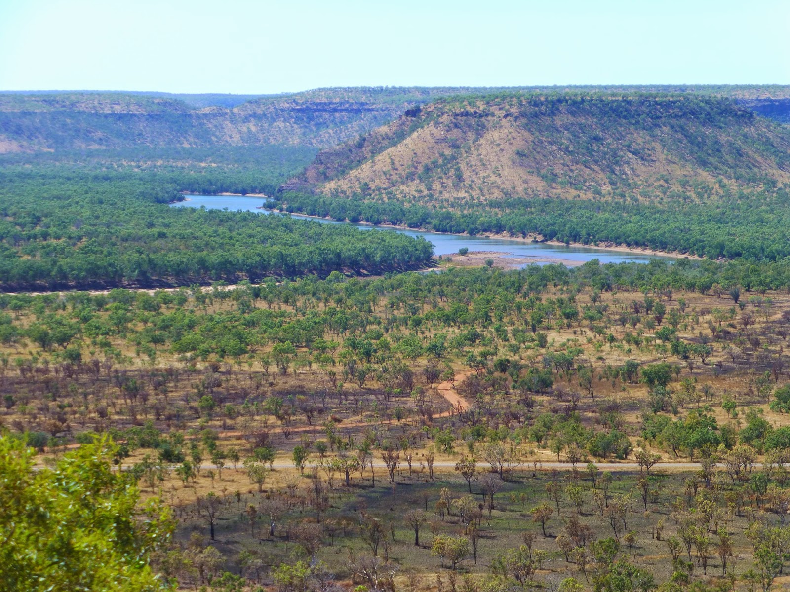 |
| Victoria River from Mountain Lookout |
Western Australia enforces stringent Quarantine Control measures over
fresh fruit and vegetables so Audrey spent time here making up a huge Stew to
use up our supply of these, and by now our anticipation of WA adventures was
paramount.
So
next morning, we drove the last 150km of the Northern Territory, through open
forest grazing country, had a trouble-free border crossing and arrived at the
Kununurra Showgrounds Campground late morning, setting our clocks back 1 ½
hours to WA time.
Kununurra Township was ‘born’ just 50 years ago, being the
service centre for the newly developing Ord River Irrigation Scheme in 1963,
has a population of around 7500, and is a well equipped modern town.
Australia’s
largest artificial lake was created in 1972 by the damming of the Ord River
across the southern end of Carlton Gorge, to provide water storage for the Ord River
Irrigation Area (ORIA), 14,000 hectares of irrigated crops, including melons,
mangoes, pumpkins, sandalwood, chia and seed crops, and with a further 13,000
hectares currently under development.
They’re big numbers in any agricultural language!
We
checked out the local tourist attractions of Kelly’s Knob Lookout - with its
scenic views over town and Ord Valley, Celebrity Tree Park – an arboretum
planted by visiting celebrities, Lily Creek Lagoon and the Kununurra Museum.
A highlight of the entire trip occurred yesterday when, in perfect weather, we took a scenic Seaplane flight over the Bungle Bungle Range with a landing on Lake Argyle for afternoon tea. Bruce sat beside the Pilot snapping photos, but difficult shooting thru the windows. The following are a few snaps to give you an idea, in haste, since we want to send this off today before departing tomorrow, Sat 14 June, on the start of our real Kimberley adventure.


Cheers 'til next time.
Bruce and Audrey
Kununurra 13/6/2014
 | ||
| Kununurra from Kelly's Lookout |
 |
| Boab Tree |
 |
| The Bungle Bungle Range |
 |
| Lake Argyle |
 | ||
| Ord River Irrigation Farms |
Bruce and Audrey
Kununurra 13/6/2014