“K K K”
No: 12
Homeward bound via
Inland SA and Western NSW
Even though the Nullarbor Plain is loosely described as
stretching 1200km from Norseman
WA to Ceduna SA, its land types
and topography vary significantly along its lower highway route, encompassing
mature forest, semi-arid saltbush plains, hilly scrublands, open grazing
pastures and farmlands cultivated to grain.

The vast open Nullarbor
Plain lands (‘null arbour’ - no trees) lie farther north of the highway. We saw
no domestic livestock at all, only birds, 2 lizards, one snake and, sadly,
three dead (road-kill) Wombats.
 |
| Eastern Nullabor Plains |
We enjoyed the Nullarbor and
its changing scenery, from arid to grasslands, passing thru 200km of grazing country, then the
western extremes of SA’s huge grain belt approaching Ceduna, with its Quarantine stop some 486km in from the WA border,
but only took a quick look around this busy coastal town with its charming old
stone architecture.
After refuelling, continued
along the Eyre Highway
inland through continuous wheat farms, in to the grain-hub village of Wirrulla
with its large grain silos.
All around Australia, town Councils vary in
their attitude to caravaners – some welcome, others shun – and tiny Wirrulla is a shining example of the
former. A concrete pad with power, toilets and hot showers is provided for $10
per day, adjacent to the supermarket and pub, and you can’t get much better
than that!
Following a 7 degree cold
night at Wirrulla we drove 70 km through more wheat before arriving at Wudinna with its huge grain storage
facilities, and a striking granite statue, which acknowledges the district’s
importance as a granite quarrying centre.
 |
| Wudinna Grain Silos |
 |
| Granite Statue at Wudinna |
 |
| Expansive Grain Growing |
Got an early start next
morning passing through fertile farmland again until Lake
Gilles Conservation
Park where the land changed to hilly
forest ridges, then flattened out to low saltbush scrub plains as we neared Iron Knob, birthplace of Australia’s
iron ore and steel industry.
Iron Knob
is almost a ghost town now with only a handful of residents, but the original two
mines of Iron Knob and Monarchs still operate on a “FIFO” basis, having produced
non-stop since the discovery of exceptional quality iron lodes in the 1890’s.
Talk is that Iron Knob’s mineral
reserves will last only a further 25 years and the already unkempt empty houses
and buildings which dot its few streets will be joined by the rest of this tiny
village to become a ghost town. The modest, though informative local museum
details the mines’ history and rewards its few visitors with free coffee or tea
in appreciation!
 |
| Iron Knob |
 |
| Iron Knob Museum |
 |
| Horricks Pass - Flinders Range |
Two hours later we’re back
on the road driving through poor country of saltbush and flat claypans and on
into Port Augusta at the head of Spencer Gulf. Backed by the Flinders
Range, the town boasts early settlement history, but apart from
quick fuel and supermarket stops, we didn’t linger here.
 |
| Main Street Wilmington |
The country around Port
Augusta is influenced by the Flinders Range, which was presently quite green as
we drove up through scenic Horrocks Pass
and on thru Wilmington, after which
the grain belt returned all the way to Orroroo,
a pretty, well-kept prosperous looking town with lovely gardens down its
clean main street, and is a credit to its residents.
 |
| Massive Red Gum |
Open green farmlands, then we came upon a giant red gum tree, said to be over 500 years old, with a girth exceeding 10 metres. Then on through Peterborough, noted as a railway town being the intersection of the E-W (Port
Pirie-Broken Hill) and N-S (Alice Springs –Adelaide) railway lines. Its original name Petersburg was changed in
1917 due to anti German sentiments.
 |
| Welcome to Peterborough |
Here we joined the main Barrier Highway
connecting Adelaide
with Broken Hill, and open pastures grazing sheep replaced the grain belt, as
we continued on to Yunta, little
more than a roadhouse in this sparse outback of central South Australia.
A further 35km brings us to Manna Hill, with its lovely old railway
station, perhaps ten houses and an old pub, whose front yard humorously
displays a “legal Pot tree”, and where we spent the night in their rest area,
sharing it with a young attractive Sydney girl, who arrived just after dark,
enroute to her work in Alice Springs, travelling and sleeping alone in her old
Volvo station wagon!
Sat 30/8: day 147. We’re out
of Manna Hill by 8:20am and back into semi-arid and flat scrub plains as we
continue on, through the wee hamlet of Olary
comprising only three very old stone buildings; further down the highway we came
across another bit of Aussie roadside humour, a Hills Hoist clothes line on a
creek-bank mound, with all the washing pegged out, complete with laundry
basket, and not a house for miles around.
 |
| Manna Hill Railway Station |
 |
| In the middle of nowhere!! |
A little further along we
arrive at Cockburn on the SA–NSW
border and stop for a quick look and photo – nothing much to see here, so drive
on through more poor hilly scrublands; however, as we continued the country
improved, though still semi-arid red country, basically the bottom end of SA’s
Strzelecki Desert, all the way to Broken Hill.
Broken Hill, “the grand dame of the
outback” with a population of 33,000 is home to BHP Billiton, the world’s largest mining company, and dates from
fairy-tale beginnings in 1883 when Charles Rasp, a station-hand boundary rider
pegged a 40 acre mining claim, thinking he might have discovered tin, thereby
sowing the seed that flourished to become this nations richest company and the
world’s richest source of silver, lead and zinc.
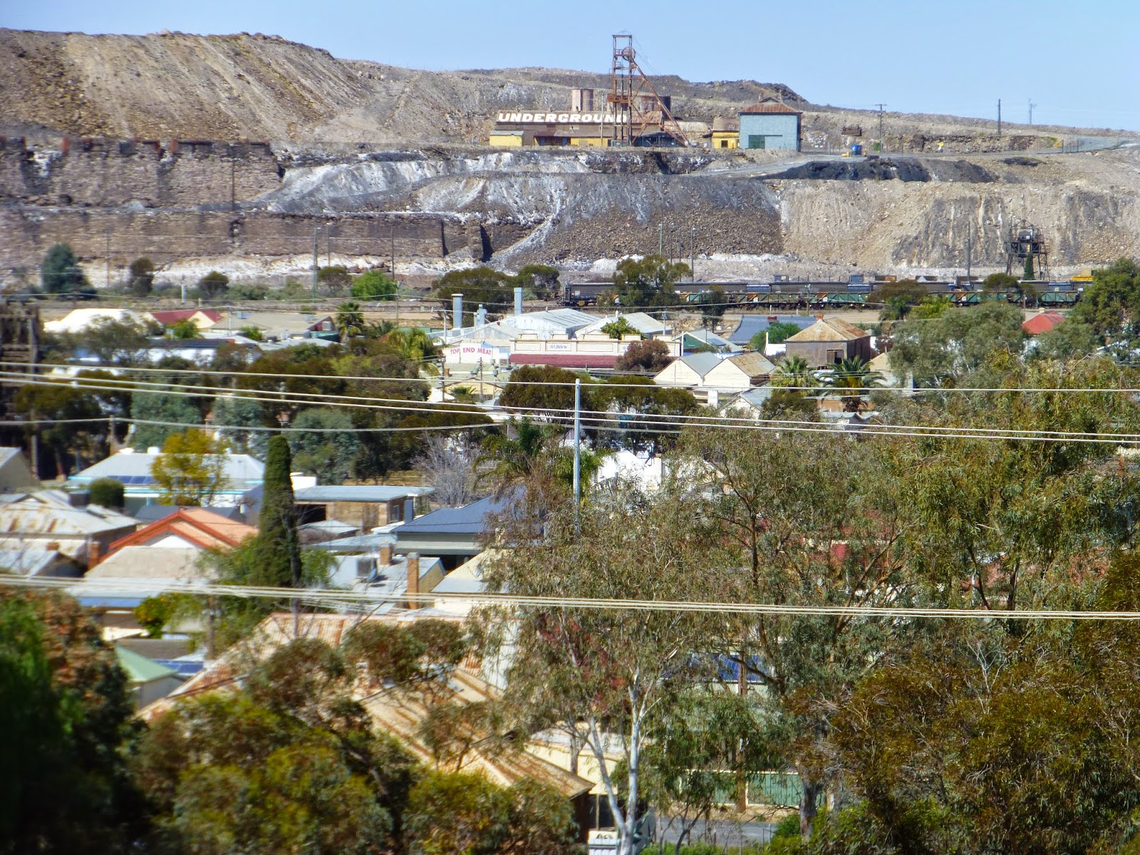 |
| Overlooking Broken Hill |
When Charles Rasp told his
boss George McCulloch, the station property owner about his find, McCulloch
suggested they form a syndicate, comprised of seven of the sheep station’s employees
to fund its development. Each invested £70 to form BHP in 1875 and the value of their original shares today would be
in excess of a billion dollars each.
After more than 130 years
mining a 300 million tonne mineral system, both town and company are still going
strong. Broken Hill is a typical old mining town with many grand old, heritage
listed buildings, together with many, many small miner’s cottages all adding
their charm to the character of the place.
We toured the city, lunched
at the central lookout, then departed mid afternoon and drove 200km to Wilcannia where we spent three days in
Victory Van Park in nice grassy surrounds shaded by giant red river gums on the
bank of the mighty Darling
River, the nations longest at 1472km.
Way out in the middle of
nowhere, Wilcannia in 1860 was Australia’s third largest port after Sydney and
Morpeth near Newcastle;
in 1887, 218 river barges arrived and left here. There were more than a dozen
hotels and a pop. of 13,000, and by 1880 there were 3000 people and 13 hotels.
Today’s pop is 600, of whom 500 identify as being aboriginal.

 |
| Wilcannia's Historic Buildings |
Wilcannia has for years been
known as a ‘trouble town’ and has the highest ratio of Police in all of NSW.
Sadly, Wilcannia now relies on government welfare to exist, having little local
economy, but its former legacy is apparent today on streets lined with historic
architecture.
2 Sept, (day 150) we depart Wilcannia after (rare) 5mm rainfall overnight and drive through the 12km wide soft riparian soils that comprise the Darling River flood plain; then climbed up into higher, hard red country of timbered rolling ridges which in turn became red Mulga scrub before changing again to open forest grasslands timbered with Box and similar eucalypts.
2 Sept, (day 150) we depart Wilcannia after (rare) 5mm rainfall overnight and drive through the 12km wide soft riparian soils that comprise the Darling River flood plain; then climbed up into higher, hard red country of timbered rolling ridges which in turn became red Mulga scrub before changing again to open forest grasslands timbered with Box and similar eucalypts.
250km bought us to Cobar, a very progressive town of 5000
with a copper mining background from 1870. Had lunch and a look around then
took the Kidman Highway north
for approx 51km, to where we had read about a nice off-road free camp, well
back from road noise, on clean, flat red soil in open Mulga, with lots of
firewood – one of our best camp spots yet. We stayed there two nights all to
ourselves, ran the 240v generator for the computer and commenced this report.
 |
| Roaring log fire and wide open spaces! |
By now we were becoming like
an old horse that can ‘smell’ home and wanted to be there, so we stopped for a
quick look around Bourke with its
old wharf on the Darling River and
some lovely old well kept homes, then pressed on through more Mulga country,
seeing hundreds of wild goats grazing the sweet grass in the table-drains all along
the next 97km stretch.
 |
| Post Office - Bourke |
Next stop was the
traditional aboriginal town of Brewarrina, pop
2000, renowned for its aboriginal fish traps, said to be 40,000 years old and
thought to be the oldest man-made structure on earth. This elaborate network of
rock weirs and pools, built to catch fish as they swam upstream, stretches for
around 500 metres along the Darling riverbed at the back of town, and continues
to lure fish today.
We continued along the Kamilaroi
highway passing through productive black soil western plains grazing country
and much dry, fallow cultivation for the 132km run to Walgett, home to the largest temporary wheat storage (30000 +
tonnes) in the Southern Hemisphere. Walgett has a significant aboriginal
community, and an 8.5km levee bank which completely surrounds the town. We camped
the night there in the Rotary caravan park.
 |
| Highway scenery |
Friday 5 Sept (day153) we
departed Walgett and took the Gwydir Highway 75km
(surely Australia’s
roughest bitumen road) thru Collarenebri,
a sad looking, small run-down whistle-stop of a place and continued a further
140km to Moree; the farther east we
travelled the better the country became.
 |
| Droving cattle near Moree |
We thought Moree was the prettiest, tidiest, best
presented country town we passed through in our ‘round Australia’ trip. Situated on the
black soil Moree Plains it is the centre of an expansive agricultural area
extending northwards to the Qld border, and is also Artesian Water country.
 |
| We saw many different country Mail Boxes |
Following a good look around
we headed up the rough Newell Hwy
to cross the Queensland
border at Goondiwindi, another well
kept attractive town. By now we were within easy distance of Brisbane, so
changed our plan for one last ‘country overnight’ stop, and after passing thru
dark rainy skies at Warwick which
further influenced our decision, we arrived back home at Cannon Hill that evening, ever grateful for a fabulous 5
month around Australia touring experience loaded with many happy memories.
153 days; from 6 April - 5
September 2014
Distance traveled 18,424km
Distance traveled 18,424km
3,900 litres Petrol cost
$6,694.35:
Price range; $1.39 - $2.50 /litre
Price range; $1.39 - $2.50 /litre
Avg: 21.17 litres per
100km.
74 paid nights ($2030) and 79 free camping nights
74 paid nights ($2030) and 79 free camping nights
Farewell until our next
adventure
Bruce and Audrey
9 Sept 2014

